Wildfire Predictive Services
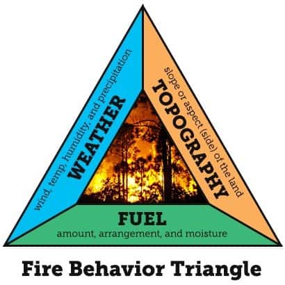
Knowing how a wildfire may behave is key to control and management. Many factors affect how a wildfire burns, how fast it moves and how difficult it is to control. The three sides of the fire behavior triangle are weather, topography and fuels.
Weather includes wind, temperature, cloudiness, moisture and air pressure. High temperatures and low humidity cause vegetation to dry and wildfires to burn rapidly. Wind not only moves wildfires across landscapes, but also supplies oxygen that can cause fires to grow swiftly. Wind also blows embers for miles, igniting new spot fires. Rain and high humidity can slow or extinguish fires, while storms can cause fire activity to increase or become completely unpredictable.
Topography is the physical features of an area, including slope and aspect (the direction it faces). Wildfires burn more rapidly when moving up a slope by preheating unburned fuels and making them more combustible. Wind also moves more rapidly up slopes, increasing the speed at which a fire can spread. Draws can act like chimneys and funnel flames upwards. South- and west-facing slopes have drier fuels than north- and east-facing slopes.

Fuels are vegetation and structures. Their characteristics have a great effect on wildfire behavior. Large, dense trees burn for hours and generate a lot of heat. Dried grasses, on the other hand, produce a flashy fire that burns quickly and does not generate much heat.
Fire Weather Program
The Department maintains nine Remote Automated Weather Stations (RAWS) in strategic locations throughout the county to monitor and record fire weather conditions. These units are located in San Marcos Pass, Mission Canyon, the Carpinteria foothills, Refugio, Gaviota, Santa Ynez Valley, Burton Mesa, Tepusquet, and the Cuyama Valley. There are five additional RAWS units maintained by partner fire agencies. The locations of all RAWS units in Santa Barbara County are displayed on the map below.
RAWS data can be accessed on the internet at: https://mesowest.utah.edu/cgi-bin/droman/mesomap.cgi?state=CA&rawsflag=3.
The National Weather Service Los Angeles also displays RAWS data for the Southern California region: https://www.weather.gov/lox/fwmV3?wfo=lox&net=1,2

Live Fuel Moisture Program
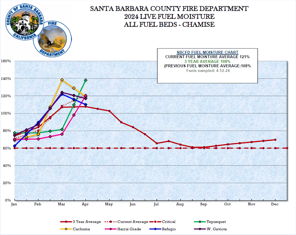
Sixty percent of live fuel moisture (LFM) is considered critical and can cause extreme wildfire behavior.
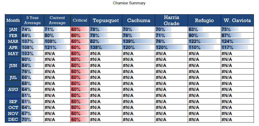
The direct measurement of LFM is done by collecting fresh field samples of Chamise, drying them until all moisture is evaporated, and calculating the water content difference between fresh and dry samples. Field-sampled LFM are gathered at five locations throughout Santa Barbara County. They include Tepusquet, Harris Grade, Cachuma, Refugio and W. Gaviota. These sites are displayed on the Fuels and Weather Map above.
How can fuel have more than 100% moisture?. Moisture content of wildland fuels is expressed in relation to dry weight, not just the proportion of water in the fuel. It is the dry material that provides the heat to evaporate water so that the fuel will burn. The definition of moisture content used here is the ratio of the weight of the water contained to the dry weight of the material, expressed as a percentage. BLM handbook
Chamise is one of the most common shrub species found in southern California chaparral communities. Chamise is evergreen, but it is sensitive to seasonal drought. During southern California’s long dry season, Chamise leaf moisture content drops as soil water availability declines. In extreme conditions, rapid dry down can happen in days, for example during Santa Ana winds affecting southern California.
Latest LFM levels for Santa Barbara County

Current Chamise Summary

Previous Years’ LFM & Chamise Summaries
For general questions about hazard reduction or vegetation management, contact (805) 681-5500.
